Tag Archives: earthquake

Earthquake cloak

Metamaterial cloaking, the idea of hiding an object using special materials, has become a popular area of research in recent years. Optical cloaks attempt to hide objects from visible light, thus making them invisible. Audible cloaks attempt to hide objects from sound waves, thus making them undetectable by (for example) sonar. Attempts at cloaking also exist for other waves; for example trying to make objects invisible to radar, which has obvious military applications.

If cloaking can work for electromagnetic and sound waves then it may also be possible to make it work for seismic earthquake waves.

The metamaterials used in cloaking have negative refractive indices and so waves do not travel through them in the normal way. All metamaterial cloaking methods work by bending waves around an object and returning them to their original paths, so that it appears that the object was never there. If the same thing could be made to happen for seismic waves around a building, then it could completely isolate the building from the seismic waves’ destructive effects.

In February of this year Sang-Hoon Kim of Mokpo National Maritime University in South Korea and Mukunda Das of the Australian National University in Canberra proposed* a way of doing this. Their method involves creating sixty metre-wide “shells” of specially constructed concrete pillars in the ground around a building, and unlike previously suggested methods doesn’t involve aiming or deflecting the waves at other buildings in the area. They suggest that their method would be able to absorb the energy of the earthquake waves, essentially stopping the waves in their tracks by transferring their energy into sound and thermal energy. A later paper†, by the same authors suggests using a similar method to create an artificial “shadow zone” in which the earthquake waves are not felt.

* Sang-Hoon Kim and Mukunda P. Das, “Seismic Waveguide of Metamaterials”, arXiv:1202.1586.

† Sang-Hoon Kim and Mukunda P. Das, “Artificial Seismic Shadow Zone Created by Metamaterials”, arXiv:1210.5589.

Thanks to KS for the inspiration for this post.
Japan’s atmosphere heated before earthquake struck

For a long time there have been reports of “earthquake lights”, aurora-like lights or colours that appear in the sky during, or just before, earthquakes. Their existence is not widely accepted, but a group of US and Russian researchers claim to have discovered a different earthquake-related atmospheric effect.

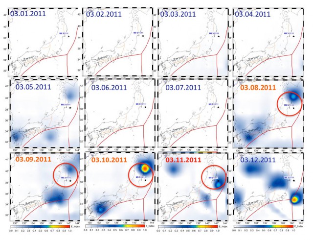
After the March 11 quake in Japan the researchers looked at atmospheric data from the days before the quake struck, and their data appears to show a noticeable heating effect in the atmosphere beginning three days before the quake.*

Red lines indicate tectonic fault lines and the star indicates the location of the March 11 earthquake.

The article claims that this heating is due to a complex mechanism called the lithosphere-atmosphere-ionosphere coupling mechanism, in which the lithosphere (the rocky crust of the Earth), the atmosphere (the layers of gas surrounding the Earth) and the ionosphere (a layer of the atmosphere that contains particles that have been ionised by the Sun, where aurora occur) interact with each other.

They posit that small movements of the crust that occurred before the earthquake released radioactive radon gas (created by the radioactive decay of uranium and thorium in the crust) that was trapped there. This radon gas (either Rn-220 or Rn-222) is a highly-ionising alpha emitter. The researchers propose that the radon creates ionised particles in the air that cause water molecules to condense out of their vapour state. This condensation process releases energy, causing the surrounding atmosphere to increase in temperature.

Dimitar Ouzounov et al. 2011. “Atmosphere-Ionosphere Response to the M9 Tohoku Earthquake Revealed by Joined Satellite and Ground Observations. Preliminary results” arXiv:geo-ph/1105.2841v1

* Not everyone agrees with their data.

Interferometry data from Christchurch earthquake

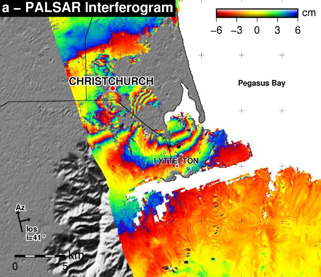
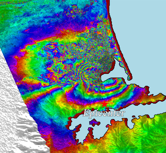
The PALSAR instrument aboard the Japanese Advanced Land Observing Satellite (ALOS) has produced some imagery of the Christchurch earthquake.

The ALOS-PALSAR instrument is an interferometer (technically an InSAR instrument) that measures the height between the satellite and the ground. The coloured bands show the variation in the height of the ground. One complete cycle of colour shows a displacement of the ground from −6 cm to +6 cm from the position it “should” be in.

Where bands are closely packed together the displacement of the ground is varying a great deal in a small distance, usually leading to greater destruction.