Monthly Archives: April 2012

Where is the best place to launch a rocket from?

NASA has quite often had to “scrub” (cancel) launches from the Kennedy Space Center (KSC) in Florida because of inclement weather. But why build a Space Centre in Florida in the first place? It’s location makes it particularly vulnerable to hurricanes and other weather “events” so there must be a significant advantage to its location.
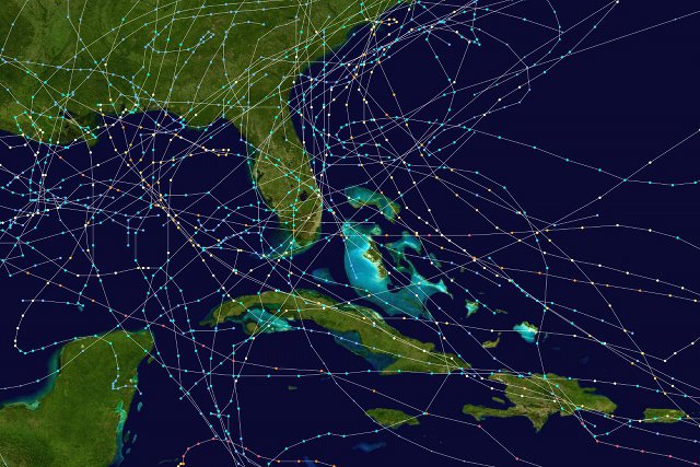
The paths of the eighty-three Florida hurricanes that occurred between 1975 and 1999.

Florida is a good location for rocket launches because it is both on the east coast of the US and because it is close to the equator.

Launching from the east coast of the US means that the rocket can take advantage of the Earth’s west-to-east spin. If a rocket were launched from the west coast it would either have to fly right across the continental US, which would be dangerous if it malfunctioned; or it would have to take off east-to-west, flying against the spin of the Earth.

At the North or South pole the speed at which you are moving, relative to a stationary observer not on Earth, is zero. As you move closer to the equator this speed increases, until at the equator you are travelling at a speed of 465 metres per second (1040 mph). At KSC, which is at a latitude of 28°N, this speed boost is reduced slightly, to about 410 m/s (916 mph). This is the best possible location in the continental USA, presumably more suitable (i.e. more southern) locations in Hawaii, Puerto Rico or one of the US’s other territories were discounted because of their remoteness.

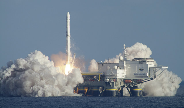
The closer to the equator you can get, the greater the speed boost you receive. This reduces the amount of energy required to get into space and means that less fuel is required. The European Space Agency makes its launches from the Guiana Space Centre in French Guiana which is only 5° north of the equator. The commercial space launch service Sea Launch uses a mobile launch platform that sails nearly 5000 kilometres from Long Beach in Los Angeles where the rockets are assembled, to a location actually on the equator where the launches take place.
Transporting the Shuttle

The Space Shuttle always launched from one of the two launch pads at the Kennedy Space Center’s Launch Complex 39.

But until the tenth mission (STS-41-B) the Shuttle always landed at Edwards Air Force Base in California, more than 3500 kilometres away on the opposite coast of the US.

So how did the Shuttle get back from Edwards to Kennedy? It cannot fly like an aeroplane because it has no conventional engines, only rocket engines powered by fuel contained in the giant orange external tank and two reusable solid rocket boosters. Whenever the Shuttle came into land it was not in powered flight like an aeroplane, but rather gliding, without any engine power at all – it relied on a large drag chute to come to a halt after touching down.

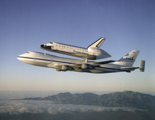
In order to get from Edwards to Kennedy the Space Shuttle was attached to a modified 747 known as the Shuttle Carrier Aircraft (SCA) and flown right across the US.

The Shuttle Atlantis mounted to the SCA. Note the aerodynamic cover placed over the main engines.

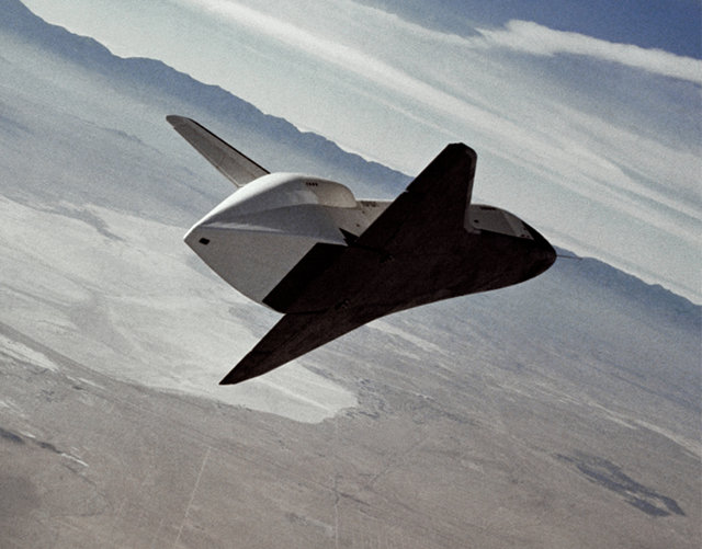
During the testing phase the Shuttle prototype Enterprise was deliberately released from one of the SCAs in mid-air and glided to a landing at NASA’s Dryden Flight Research Center.

The Shuttle Enterprise glides over the California desert after being released from the SCA.

Clockwise

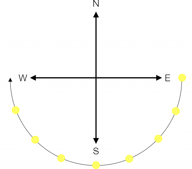
Because the Earth rotates west to east, no matter where on Earth you are, the Sun rises in the east and sets in the west. In the northern hemisphere it passes through the south as it travels across the sky*, and in the southern hemisphere it passes through the north.

The first clocks that displayed the time (rather than measuring intervals of time) were simply sticks inserted vertically into the ground (gnomon). As the Sun moved across the sky the shadow cast by the stick would move across the ground; at midday the Sun would be at the south and the shadow would point north, to the “twelve o’clock” position.

An interesting consequence of this relates to the convention of “clockwise”:
If the development of the first clocks taken place in the southern hemisphere rather than in the northern hemisphere, clockwise and anticlockwise would be in opposite directions.

* Hence why, in the northern hemisphere, a south-facing garden is an attractive selling point for a house.

Why kettles boil slowly in the US

I saw a tweet recently that intrigued me:

http://twitter.com/#!/yoz/status/191445005414567937

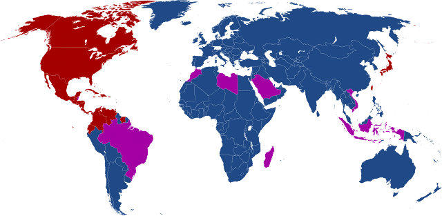
The voltage of mains electricity varies from country to country: the majority of countries use between 200 and 240 volts, but a small minority (most notably the US, Canada and Japan) use between 100 and 127 volts.

Countries using 100-127 volts are shown in red; countries using 200-240 volts are shown in blue. Countries with a mixture of the two systems are shown in purple.

The voltage* of an electrical supply is what pushes electrons around in a circuit. The higher the voltage, the faster the electrons move and thus the higher the current (one amp is equivalent to about six billion billion electrons flowing past a point per second). With a low voltage the rate of transfer of electrical energy is therefore much slower. In the UK, with a mains voltage of 230 V and a limit of 13 A per socket the maximum possible power to one appliance is 2990 watts (2990 joules per second). In the USA, with a mains voltage of 120 V and a limit of 15 A per outlet the maximum possible power is reduced to only 1800 watts, which is why in the US many large appliances (e.g. washing machines, tumble dryers) have to be connected to a separate high-voltage circuit.

To raise the temperature of one litre of water from 15°C to boiling at 100°C requires a little bit over 355 kilojoules of energy. An “average” kettle in the UK runs at about 2800 W and in the US at about 1500 W; if we assume that both kettles are 100% efficient† than a UK kettle supplying 2800 joules per second will take 127 seconds to boil and a US kettle supplying 1500 J/s will take 237 seconds, more than a minute and a half longer. This is such a problem that many households in the US still use an old-fashioned stove-top kettle.

* As a physicist I would normally use the term “potential difference” in place of “voltage” but voltage is better understood by the general public. Looks like the engineers (who prefer “voltage”) won that battle.

† As electric kettles actually use the joule heating effect that is responsible for most of the energy wasted in other electrical devices this isn’t a terribly unfair assumption.

Poverty and the wind

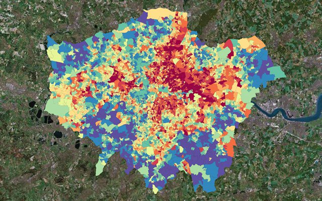
A map of poverty* in London clearly shows a clustering of poorer areas to the north-east of the city.

There is a very simple reason for this, and it’s the same reason that poorer areas are found towards the north and east of most large and old towns in the UK: the prevailing wind.

Because of its position to the north-east of the Atlantic Ocean, the prevailing wind in the UK is from the south-west (i.e. blowing north-east). Any atmospheric pollution produced in London – and in the 1800s and 1900s that was be a lot of pollution – would be blown to the north-east, making that area less attractive and therefore cheaper to live in.

You can explore poverty in the UK using the interactive Google Map below, which I found via a story in The Grauniad:

* The data used is the 2007 Index of Multiple Deprivation, and the mapping is by London Profiler.