The average radioactive background dose in the UK is 2.7 millisieverts. Of this 2.7 mSv, 1.35 mSv comes from radioactive radon gas leaking out of the ground.

This radioactive radon (Rn-222) is produced by the decay of uranium-238, after a series of intermediate non-gas stages that cannot escape from rocks.
![]()
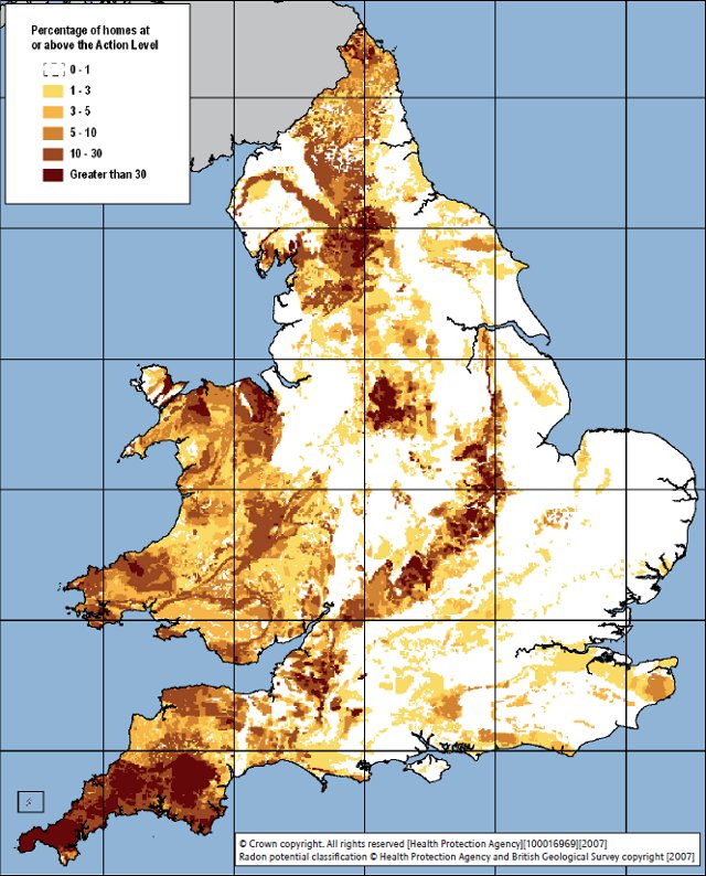
Because radon has such a large effect on the annual radiation dose that someone receives, it is closely monitored. In the UK, this monitoring is done by the Health Protection Agency (HPA). One of the things that the HPA does it produce radon maps, showing which areas of the UK have the highest presence of radon.

The map is graded by the percentage of homes in that area which have a level of radon beyond the action level of 200 becquerels per cubic metre (200 radon decays per second per cubic metre).
There are a number of important radon hotspots in the UK. The most noticeable one is Cornwall in the south-west where the average UK background dose is 7.8 mSv, nearly three times the national average. This is due to the presence of igneous granite, which naturally contains more uranium (10-20 parts per million) than other rocks.
Radioactive areas tend to be hilly, where igneous rocks have been forced to the surface or left behind by the erosion of softer sedimentary rocks (the Chiltern Hills are particularly radioactive, for example). The Yorkshire Dales sit on top of an underground deposit of pink granite called the Wensleydale Granite that lies underneath the Askrigg Block, and the Peak District features many granite outcroppings.